We Found You!!
We have located you in the region.
Navigate to the view diary button to switch to a diary at this location.You can change directories at any time by clicking on the Choose a Region button
Search Community Directory
Warialda, New South Wales
Local Services in Warialda
Upcoming Events in Gwydir
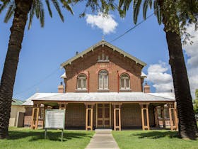
Warialda is an idyllic country town with some fine late nineteenth century architecture and is a thriving agricultural hub for neighbouring towns and villages. Surrounded by state forest and national park, majestic stands of Angophora can be seen within walking distance of the town centre, and an excellent public pool allows you to cool off at the end of the day. It is a mecca for bird watchers and naturalists. Warialda Creek, also known as Reedy Creek, flows through the town and is a great spot for checking out small birds or having a quiet walk. Warialda is home to a number of great community events, that are mainly run by volunteers with contributions from local businesses and Gwydir Shire Council. The Honey Festival, Christmas Carnival, Pony Club, Campdraft, Races and the famous Warialda Off Road event are just some of the many draw cards to the area. The three day agricultural show in May is considered to be one of the best in the North West, and the nine hole, eighteen tee golf course is very popular with regional golfers. The Pioneer Cemetery at the southern end of Stephen Street is a good starting point to explore Warialda’s historical sites. The cemetery contains graves dating back to the 1850s, and there are massive memorials to the Scott family of Bogamildi which show how much money was to be made out of sheep in those far off days. Many headstones have vanished, but a comprehensive list is on display, and there are some fine smooth barked apple trees in the vicinity. The modern Anglican Church on Stewart Avenue is home to a historic font, commemorating the medical pioneer Sister Elizabeth Kenney who was baptised in the old church on Gwydir Highway in 1880. St. Patrick’s Church and the attached convent also on the Gwydir Highway were built in 1904, allowing students to board with the sisters whilst attending school in the town.
Postcode: 2402Area: 2448.40 km2LGA: Gwydir CouncilPopulation: 1713